| [to Baden's Home Page] |
This page is updated regularly (yeah, sure you say) to reflect current
![]() conditions.
conditions.
If you would like sunset charts for anywhere, just e-mail me, and I'll send them to you.
Stats from 2024-12-01 0:00 CST to 2025-05-10 0:00 CSTUnits are metresVANCOUVER (81-11-03) (index number: 7735)
Extreme Tides to 2037Vancouver: Sorted by height | datePoint Grey: Sorted by height | date Puerto Escondido: Sorted by height | date
|
||||||||||||||||||||||||||
Also, I found an excellent primer from the NOAA on Tides, explaining the Astronomical Factors, Tides and Tidal Currents
I also downloaded the new harmonics.canadian file (1.1 MB), which contains over 1000 Canadian locations, using 61 harmonic constituents for which I now use for my data. This file has data for the following localities, which are not generally available without the above file:
If you would like tide charts for any time or place, just mail me, and I'll process, then send them to you.
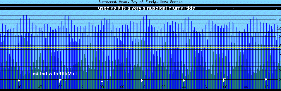
You can put out text or graphic data, which is real neat, and there are many switches to allow you to show almost anything you want. I was able to run a 200 day graphic, to show that the moon's phases do not coincide with the tides, as I had been told, but rather appear to lag the lunar cycle by a few days. My conjecture is that the lunar orbit's eccentric axis is aligned about 45 degrees ccw from the sun to earth's normal.
TIDE 1.5 for OS2
(other platforms) and real full README
This is an OS2 port by Dale DePriest of the tide program written by David Flater. This program will compute accurate tides for many areas thoughout the world. This port requires emxrt.zip be installed and was built with EMX 0.9c with fix01. [you should get this anyway, as more and more and more unix ports use it]
This version of tide can generate ascii graphics and text output as well a ppm graphic output, all which have time zone and units support. You should be able to view the graphics with a suitable graphic program such as PMView.
Other
Platforms
Q: "Has this been ported to Windows / OS/2 / anything but Unix?"
A: Yes, to varying degrees. The TTY-only client compiles as-is under EMX on OS/2 and DOS thanks to Dale DePriest, and is alleged to compile without modification under Windows NT. Binaries for OS/2 and DOS are available; refer to the Installation section for more information. The graphic client was ported to Microsoft Windows by Paul C. Roberts (paul@slothdom.demon.co.uk) and/or Alex (alex@slothdom.demon.co.uk); the modified sources and binaries are available at ftp://ftp.demon.co.uk/pub/ibmpc/win3/apps/wtide.
The TTY client was ported to the Macintosh by Mikhail Fridberg (fridberg@pfc.mit.edu); the modified sources and binary are in ftp://ftp.flaterco.com/xtide/MacTide133sit.hqx (binhexed Stuffit archive).
PLEASE NOTE: Ports of XTide to non-Unix platforms are supported by the people who
did the ports. I am only responsible for fixing bugs in the original Unix sources.
| [to page top] |