seismograph
| [to Baden's Home Page] |
2024-01-18 Huatulco Earthquake
2022-03-01 Pochutla Earthquake
2020-06-23 Huatulco Earthquake
2018-02-16 Pinotepa Earthquake
1998-02-03 Huatulco Earthquake
1997-06-24 Howe Sound Earthquake
Magnitud    Fecha y hora (CST)      Epicentro localización:                         latitud longitud    Profundidad

4.3 	    2024-02-25 09:23:24     23 km al SUR de PUERTO ESCONDIDO, OAXACA         15.65°  -97.07°     5.8 km
Magnitud    Fecha y hora (CST)      Epicentro localización:                         latitud longitud    Profundidad

4.6 	    2024-02-24 18:57:28     51 km al SURESTE de PUERTO ESCONDIDO, OAXACA         15.45°  -96.86°     16.2 km
Magnitud    Fecha y hora (CST)      Epicentro localización:                      latitud longitud    Profundidad

5.0 	    2024-01-18 08:40:16     35 km al SURESTE de CRUCECITA, OAXACA         15.51°  -95.94°     26.7 km
Magnitud    Fecha y hora (CST)      Epicentro localización:                         latitud longitud    Profundidad

5.5 	    2023-04-03 20:11:59     17 km al NORTE de PUERTO ESCONDIDO, OAXACA         16.01°  -97.06°     26.7 km
Magnitud    Fecha y hora (CST)      Epicentro localización:                      latitud longitud    Profundidad

4.4 	    2023-02-18 00:04:31     19 km al SURESTE de RIO GRANDE, OAX.         15.90°  -97.30°     5 km
Magnitud    Fecha y hora (CST)      Epicentro localización:                      latitud longitud    Profundidad

4.3 	    2022-10-04 13:54:31     18 km al SURESTE de RIO GRANDE, OAX.         15.92°  -97.30°     7 km
Magnitud    Fecha y hora (CST)      Epicentro localización:                      latitud longitud    Profundidad

4.3 	    2022-09-03 15:02:45     17 km al NORESTE de PUERTO ESCONDIDO, OAX.   15.93°  -96.92°     11 km
Magnitud    Fecha y hora (CST)      Epicentro localización:                      latitud longitud    Profundidad

5.2 	    2022-03-01 13:35:45     26 km al NOROESTE de S PEDRO POCHUTLA, OAX   15.94°  -96.61°     41 km
Magnitud    Fecha y hora (CST)      Epicentro localización:                      latitud longitud    Profundidad

4.5 	    2021-01-19 06:12:15     23 km al OESTE de PUERTO ESCONDIDO, OAX      15.86°  -97.28°     9 km
4.8 	    2020-07-01 14:54:08     28 km al ESTE de PUERTO ESCONDIDO, OAX       15.81°  -96.81°     27 KM
Magnitud    Fecha y hora (CST)      Epicentro localización:                     latitud longitud    Profundidad

4.1 	    2020-07-01 15:15:13     28 km al ESTE de PUERTO ESCONDIDO, OAX      15.84°  -96.81°     6 KM
4.8 	    2020-07-01 14:54:08     28 km al ESTE de PUERTO ESCONDIDO, OAX      15.81°  -96.81°     27 KM
Magnitud Fecha y hora (UTC) Epicentro localización: latitud longitud Profundidad Mw 7.4 2020-06-23 15:29:04.2 25 km NE of Santa Mar�a Xadani, Mexico 16.10° -95.91° 10.0 km There are big location discrepancies between UNAM and UGCS and CSEM.
Magnitud    Fecha y hora (CST)      Epicentro localización:                         latitud longitud    Profundidad

4.5 	    2020-03-11 10:49:23     33 km al SURESTE de PUERTO ESCONDIDO, OAX       15.75°  -96.79° 	15 km
4.7 	    2020-03-11 07:50:44     32 km al OESTE de S PEDRO POCHUTLA, OAX         15.81°  -96.76° 	15 km
Magnitud    Fecha y hora (CST)      Epicentro localización:                         latitud longitud    Profundidad

4.1	    2020-01-24 04:33:24     23 km al SUROESTE de PUERTO ESCONDIDO, OAX      15.71°  -97.22°     10.0 km
5.2	    2020-01-24 04:47:49     22 km al NOROESTE de PUERTO ESCONDIDO, OAX      16.01°  -97.2°      27.0 km
Magnitud    Fecha y hora (CST)      Epicentro localización:                         latitud longitud    Profundidad

5.1	    2019-11-23 20:29:07     51 km al SURESTE de PUERTO ESCONDIDO, OAX       15.46°   -96.84°    11 km
4.9	    2019-11-23 20:33:10     53 km al SUR de PUERTO ESCONDIDO, OAX           15.39°   -96.96°    17 km
4.8	    2019-11-23 20:34:40     41 km al SURESTE de PUERTO ESCONDIDO, OAX       15.57°   -96.82°    15 km
4.5	    2019-11-23 20:58:41     42 km al SURESTE de PUERTO ESCONDIDO, OAX       15.55°   -96.84°    9 km
Magnitud    Fecha y hora (CST)      Epicentro localización:                         latitud longitud   Profundidad

7.2	    2018-02-16 17:39:38     11 km al SUR de PINOTEPA NACIONAL, OAX          16.25°  -98.03°    12 km
5.9	    2018-02-16 18:36:52     46 km al SUR de PINOTEPA NACIONAL, OAX          15.93°  -97.97°    16 km
5.2	    2018-02-16 21:54:41     42 km al SURESTE de PINOTEPA NACIONAL, OAX      16.01°  -97.85°    10 km
5.3	    2018-02-17 15:30:42     11 km al SUROESTE de PINOTEPA NACIONAL, OAX     16.25°  -98.09°    11 km
6.0	    2018-02-19 00:56:57     32 km al SURESTE de PINOTEPA NACIONAL, OAX      16.25°  -97.77°    10 km
Fecha       Hora        Lat.    Long.   Prof.(Km)   Mag.    Zona

2015-04-22  23:24:58    15.97   -96.99  35.0        4.9     14 km al NORESTE de PUERTO ESCONDIDO, OAX
Fecha       Hora        Lat.    Long.   Prof.(Km)   Mag.    Zona

2010-02-25  19:52:12    15.37   -97.01  37          4.2     55 km al SUR de PUERTO ESCONDIDO, OAX
2010-02-25  19:52:14    15.82   -96.91  9           4.4     17 km al SURESTE de PUERTO ESCONDIDO, OAX
MAG  	UTC DATE-TIME	        LAT     LON     DEPTH     Region
        y/m/d       h:m:s       deg     deg     km
4.3  	2010/02/26  01:52:20    16.382 -96.533  48.9      OAXACA, MEXICO
Ironically, just a few weeks before, I made a concerted effort to harden my room against quake damage by evaluating all that could get shaken down, and moving heavier stuff closer to the floor. I did this as I thought there was too long a period without any vibration at all.
Fecha       Hora        Lat.    Long.   Prof.(Km)   Mag.   Zona
2010-02-08  18:47:40	15.9	-96.86	37	    5.8    23 km al ESTE de PUERTO ESCONDIDO, OAX
MAG  	UTC DATE-TIME	        LAT     LON     DEPTH    Region
        y/m/d       h:m:s       deg     deg     km
5.8	2010-02-08  18:47:40    15.9	-96.86	37	 23 km al ESTE de PUERTO ESCONDIDO, OAX
DATE-(UTC)-TIME         Latitude  Longitude   Depth   Magnitude COMMENTS
yyyy-mm-dd  hh:mm:ss 	degrees   degrees     km
2004-01-13  19:50:19 	16.09N 	  96.93W      28.6    5.0 	OAXACA, MEXICO
2004-01-13  21:28:59 	16.20N 	  96.91W      33.0    5.4 	OAXACA, MEXICO
2004-01-14  12:04:42 	16.22N 	  96.78W      33.0    4.1 	OAXACA, MEXICO
On 1998-03-03 at about 01:39, I was at my desk, when I first heard all the dogs start to bark, and then about 10 seconds later, I heard a deep rumble get closer and closer, and then my room really started to shake. The neat thing was that I experienced the whole thing, and if I had wanted to, I could have easily run outside.
DATE-(UTC)-TIME    LAT     LON     DEP   MAG  Q  COMMENTS
yy-mm-dd hh:mm:ss  deg.    deg.    km

98-02-03 03:01:59  15.94N  96.11W  33.0 6.1Ms A  NEAR COAST OF OAXACA, MEXICO
98-02-03 07:17:52  15.93N  96.13W  33.0 4.8Mb A  NEAR COAST OF OAXACA, MEXICO
98-02-03 13:16:37  16.68N  96.41W  33.0 4.3Mb C  OAXACA, MEXICO
98-02-07 07:12:02  16.07N  96.02W  33.0 4.4Mb B  OAXACA, MEXICO
98-03-03 07:38:21  15.90N  96.02W  33.0 4.9Mb A  NEAR COAST OF OAXACA, MEXICO
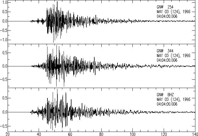
DATE-(UTC)-TIME    LAT(N) LON(W)    DEP  MAG QUAL    COMMENTS
yy-mm-dd hh:mm:ss  deg.   deg.      km

97-06-24 14:23:13  48.35N 119.88W   3.2   C  FELT F  23.6 km W of Okanogan
97-06-24 14:36:02  48.35N 119.88W   4.1   C          22.8 km W of Okanogan
It was only later that I was able to retrieve the one that hit us, and it's epicentre was actually about 40 Km north, right across Howe Sound from Britannia Beach, which correlates with damage reports from Sechelt.
DATE-(UTC)-TIME    LAT(N) LON(W)   DEP   MAG  QUAL    COMMENTS
yy-mm-dd hh:mm:ss  deg.   deg.     km

97-06-24 14:40:59  49.20N 123.60W  21.0   C   FELT F  40.4 km WNW of Vancouver
The thing that bothers me, is that until last year, I had never felt an earthquake, and now they appear to have become more common.
|
seismograph |
Well, now that you've all been shaken awake while watching Seinfeld, you may want some more information. I laugh at the disaster services, saying that we citizens should smarten up. The ambulance service was totally incapacitated, because they all evacuated their building, and the phone lines were all jammed by people talking (hey, count me in!) about it. I think I know who has to get their shit together.
 Earthquake Info from the U.S.G.S.
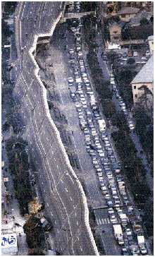
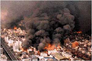
Of course, if you live in Richmond, Ladner, or anywhere else that is built on sediment, then maybe have a look at what happened in Kobe Japan, where they thought that they were prepared. This is really neat, and has has many images, thus it takes a while to load.
| [to page top] |